My fieldtrip down to the Albany and Margaret River areas of the Southwestern region of WA will probably be the most memorable experience that I take back with me when I leave Australia. It consisted of seven days, filled with hard work, which wore both on the body and mind, and late nights spent completing the maps and diagrams of certain outcrops that we spent the day studying. Through it all, however, I made wonderful friends and learned so much more, in such a short amount of time, than I ever could have in a classroom. Traversing, at times, over fairly dangerous terrain, sometimes consisting of sharp limestones that jutted out at every angle, to steep rocky slopes that abruptly dropped off into the crashing waves (of the Southern and Indian Oceans) below. It’s a miracle that my fellow classmates and myself made it back safe and sound without any more than a scratch.
The first four days were spent dodging rain drops and sheltering our detailed sketchwork, maps and field notebooks from the ever-impending shower, while managing the impossible task of keeping ourselves and our belongings dry(which we packed up each morning and lugged around the field with us all day). There were moments when I felt quite miserable and in need of dry/warm clothing and shoes. I even remember envying the instructors, with their years of experience in the field, who sat about oblivious to the weather around them. I envied their indifference.
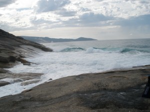
It really only affected me the most on the second day out, when we were all stuck out on a huge outcrop in Albany, known as The Gap because of its main physical feature. It consists of two stifflingly large cliffs, which have essentially been split apart by the enormous waves (that this particular area is known for) below, forming a gaping gap with very high walls.
On this day, not only did the rain pester us all day, but temperatures stayed quite low as well. We even felt it sleeting at times! We all sat around this rock pavement, with the overcast sky persistantly hovering overhead, struggling to produce detailed (and to scale) geological sketch maps, using 1 meter grid squares as the mapping base.
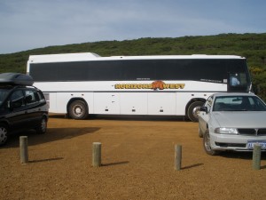
It was so bad at one point that as soon as I saw a few others heading off towards the bus (the only refuge) I took off in a mad dash after them. At that point it was more important to get shelter than it was to finish my work. It could be said that the bus was our home away from home twice removed; sometimes it seemed that we spent more time in it (travelling across the region from site to site) than we did in our beds at night.
South Western Travels
My fieldtrip down to the Albany and Margaret River areas of the Southwestern region of WA will probably be the most memorable experience that I take back with me when I leave Australia. It consisted of seven days, filled with hard work, which wore both on the body and mind, and late nights spent completing the maps and diagrams of certain outcrops that we spent the day studying. Through it all, however, I made wonderful friends and learned so much more, in such a short amount of time, than I ever could have in a classroom. Traversing, at times, over fairly dangerous terrain, sometimes consisting of sharp limestones that jutted out at every angle, to steep rocky slopes that abruptly dropped off into the crashing waves (of the Southern and Indian Oceans) below. It’s a miracle that my fellow classmates and myself made it back safe and sound without any more than a scratch.
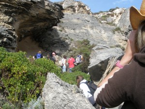
The first four days were spent dodging rain drops and sheltering our detailed sketchwork, maps and field notebooks from the ever-impending shower, while managing the impossible task of keeping ourselves and our belongings dry(which we packed up each morning and lugged around the field with us all day). There were moments when I felt quite miserable and in need of dry/warm clothing and shoes. I even remember envying the instructors, with their years of experience in the field, who sat about oblivious to the weather around them. I envied their indifference.
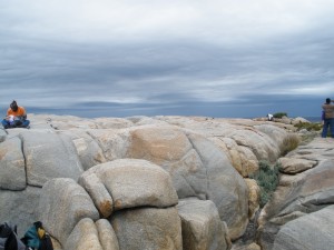
It really only affected me the most on the second day out, when we were all stuck out on a huge outcrop in Albany, known as The Gap because of its main physical feature. It consists of two stifflingly large cliffs, which have essentially been split apart by the enormous waves (that this particular area is known for) below, forming a gaping gap with very high walls.
On this day, not only did the rain pester us all day, but temperatures stayed quite low as well. We even felt it sleeting at times! We all sat around this rock pavement, with the overcast sky persistantly hovering overhead, struggling to produce detailed (and to scale) geological sketch maps, using 1 meter grid squares as the mapping base.
It was so bad at one point that as soon as I saw a few others heading off towards the bus (the only refuge) I took off in a mad dash after them. At that point it was more important to get shelter than it was to finish my work. It could be said that the bus was our home away from home twice removed; sometimes it seemed that we spent more time in it (travelling across the region from site to site) than we did in our beds at night.
To be continued…
petersa
Next ArticleIrish Countryside and...Icelandic Volcano? part 1